


st gervais balme anery

coglais
User
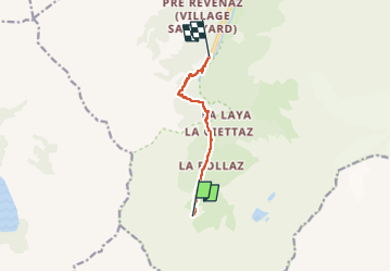

Length
7 km

Max alt
1723 m

Uphill gradient
131 m
Km-Effort
10.4 km

Min alt
1205 m

Downhill gradient
639 m
Boucle
No
Creation date :
2022-06-04 10:05:05.328
Updated on :
2022-06-04 13:51:10.449
1h51
Difficulty : Very difficult

FREE GPS app for hiking
 SityTrail
IGN / Geographical institutes
SityTrail Plus
The world is yours!
About
Trail Nordic walking of 7 km to be discovered at Auvergne-Rhône-Alpes, Upper Savoy, Les Contamines-Montjoie. This trail is proposed by coglais.
Positioning
Country:
France
Region :
Auvergne-Rhône-Alpes
Department/Province :
Upper Savoy
Municipality :
Les Contamines-Montjoie
Location:
Unknown
Start:(Dec)
Start:(UTM)
321909 ; 5069597 (32T) N.
Comments